
Measuring Greater Manchester’s Green and Blue Spaces: Creating an Urban Green Infrastructure Baseline
Like other city regions across the world, Greater Manchester (GM) is facing increasing risks from extreme weather and climate change. Green infrastructure (GI) can play an important role in reducing the impact of climate change. GI can also provide a wide range of other environmental, social and economic benefits[1], making it a useful way to increase wellbeing and quality of life in our cities and urban areas.
The IGNITION project is an innovative initiative to establish funding and delivery mechanisms to increase GM’s GI to help us adapt to climate change. To make progress with this project, partners needed to create an urban GI baseline for GM to establish how much GI already exists across the city region, and to map its current distribution. By establishing this baseline GM can monitor change in urban GI over time. It will also be used to inform decisions on where investment in new GI could be made to support climate change adaptation.
GI is “a term that describes ‘green’ features such as parks, open spaces, playing fields, countryside, gardens, hedges, trees, woodlands, green roofs, and green walls. It also includes ‘blue’ features such as rivers, canals, ponds and other water bodies.”[2] GM’s IGNITION project follows this approach, with GM’s GI encompassing a wide range of different green and blue features, which are often referred to collectively as green and blue spaces. These have been incorporated into GM’s GI baseline.
What does the baseline show?
The University of Manchester has led on the development of the urban GI baseline. It has been produced using the most comprehensive spatial data currently available for the city-region, some of which has been enhanced further as part of the baseline process. It draws on Ordnance Survey (OS) land cover data and City of Trees tree canopy cover data.
Table 1 and the infographic below summarises the baseline results for GM’s urban area[3]. It shows the area covered by green and blue spaces, and also other land cover types found across GM’s urban areas. It also shows tree canopy cover over the different land cover types that make up GM’s urban area. The baseline provides the most accurate estimate of GM’s urban GI that is currently available.
|
Land Cover Types Found in GM’s Urban Area |
Land Cover Area (km²) |
Land Cover % To GM Urban Area |
Canopy Cover (km²) |
Canopy Cover % To Total Canopy Cover |
Canopy Cover % To GM Urban Area |
|
Blue Space |
6.51 |
1.06 |
1.21 |
1.10 |
0.20 |
|
Green Space |
332.17 |
54.22 |
90.89 |
82.07 |
14.84 |
|
Other Natural |
0.14 |
0.02 |
0.02 |
0.01 |
0.00 |
|
Total |
338.82 |
55.3 |
92.12 |
83.18 |
15.04 |
|
Building |
100.74 |
16.44 |
1.64 |
1.48 |
0.27 |
|
Carpark or Manmade Surface |
94.43 |
15.42 |
8.92 |
8.05 |
1.46 |
|
Land Use Changing |
0.84 |
0.14 |
0.14 |
0.12 |
0.02 |
|
Mineral Workings |
0.17 |
0.03 |
0.01 |
0.01 |
0.00 |
|
Transport Network |
72.50 |
11.83 |
7.14 |
6.45 |
1.17 |
|
Undefined |
5.12 |
0.84 |
0.79 |
0.71 |
0.13 |
|
Total |
273.82 |
44.7 |
18.63 |
16.82 |
3.05 |
|
All Land Cover Types |
612.63 |
100.00 |
110.75 |
100.00 |
18.08 |
Table 1: Tree canopy cover over land cover types in GM’s urban area (see Table 2 for further details of land cover types)
What have we learned?
The baseline has revealed that Greater Manchester’s urban areas are often already surprisingly green places to be. There are still many areas for improvement, and the baseline helps to identify locations where further investment in GI would be valuable. Some of the key learnings emerging from the baseline include:
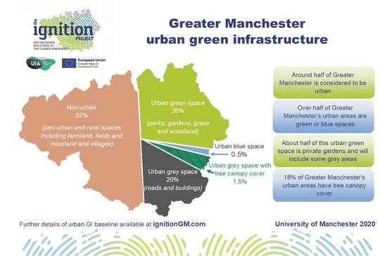
- Over half of GM’s urban area is covered by green and blue spaces.
- Tree canopy is not reported as GI under other baseline approaches, which often focus only on surface cover (e.g. the OS MasterMap Greenspace Layer). The IGNITION urban GI baseline reports on surface cover and also on tree canopy cover. This is a useful innovation and adds another dimension to our understanding of GM’s GI.
- Almost 20% of GM’s urban tree canopy is over hard surfaces such as paths, carparks and squares. These trees provide important climate change adaptation functions including shading, cooling and capturing rainwater.
- Around half of GM’s urban GI is private gardens (166.25 km² out of 332.17 km²). Private gardens are included as part of GM’s urban GI (OS classify private gardens as greenspace). In reality they are multi-surface land cover types incorporating buildings and hard surfaces alongside green spaces, meaning that a significant amount of private garden space could potentially be converted from grey to green.
The road ahead
GI currently covers 55.28% of GM’s urban area. Increasing the surface cover of GI (e.g. via incorporating green roofs on buildings or converting hard surfaces to green areas) and enhancing the functionality of existing GI (e.g. installing sustainable drainage systems and trees in grassed areas) provide ways of adapting GM to climate change. Additional investment in GI can also help to generate more benefits – environmental, social and economic – from Greater Manchester’s environment. Eleven IGNITION partners are now working to make this mission successful. Find out more about Greater Manchester’s IGNITION project here: www.ignitiongm.com
|
Land Cover Type |
Sub-categories included |
|
Blue Space |
Aqueduct:Canal, Aqueduct:Watercourse, Canal, Canal Feeder, Canal:Marsh, Conduit, Drain, Ford, Fountain, Inland Water, Lock, Lock Gate, Mill Leat, Reeds:Reservoir, Reeds:Static Water, Reeds:Watercourse, Reservoir, Spring, Static Water, Swimming Pool, Watercourse, Waterfall, Weir, Well |
|
Building |
Archway, Building, Structure: industrial structure
|
|
Carpark/Manmade Surface |
Carpark, Carpark: Manmade surface |
|
Green Space |
Allotment Surface, Boulders, Cemetery, Coppice Or Osiers, Grass, Grass:Scrub, Marsh, Marsh:Rough Grassland, Mineral Workings (Inactive), Multi Surface, Orchard, Private Garden, Rock (Scattered), Rough Grassland, Rough Grassland:Boulders (Scattered), Rough Grassland:Bridge, Rough Grassland:Scrub, Scrub, Bridge:Scrub, Scrub:Coppice Or Osiers, Scrub:Marsh, Scrub:Marsh:Rough Grassland, Scrub:Soil, Spoil Heap, SUDS, Woodland |
|
Land Use Changing |
Areas that are changing land cover type, e.g. brownfield land currently being developed |
|
Manmade |
Chimney, Conveyor, Conveyor:Overhead Construction, Crane, Crane:Overhead Construction, Cross, Manmade Surface, Slipway, Sloping Masonry, Tank, Telecommunications Mast, Upper Level of Communication |
|
Mineral Workings |
Mineral Workings |
|
Other Natural |
Bare Soil, Sand, Shingle |
|
Transport Network |
Bridge, Bridge:Step, Footbridge, Footbridge:Step, Gantry, Level Crossing, Path, Path:Structure, Rail Signal Gantry, Road Or Track, Step, Track, Traffic Calming |
|
Undefined |
Areas that Ordnance Survey have not classified as a specific land cover type |
Table 2: Sub categories included in each land cover type.
[1] https://www.greatermanchester-ca.gov.uk/what-we-do/environment/natural-e...
[2] Greater Manchester Spatial Framework (GMSF),GMCA 2019, Page 128
[3] The GI baseline data presented in this table was developed using the OS MasterMap Greenspace Layer, the OS MasterMap Topography Layer and the ESRI image layer service. Data derived from the City of Trees tree canopy and tree line layers enabled tree canopy cover data to be included as part of the baseline. Related reports, available from the IGNITION project team, provide further details on the urban GI baseline methodology, output and associated caveats. Options to make the baseline data publically available are being explored, including via the GM Open Data Infrastructure Map.
Recommended Articles:

The IGNITION Project: How We’re Getting People Switched On to Climate Change
on 09.01.2020
Contributed by Jennifer Lane
Contributed by Jennifer Lane

University of Manchester begins the re-greening of its campus
on 11.03.2016
Contributed by Steve Connor
Contributed by Steve Connor
Share this: 


Contributor Profile

Campaign Manager – IGNITION Project
Jennifer Lane is Campaign Manager for the IGNITION Project and Natural Course.